When Finding Your Way Meant Actually Learning Where You Were
The Ritual of Arrival
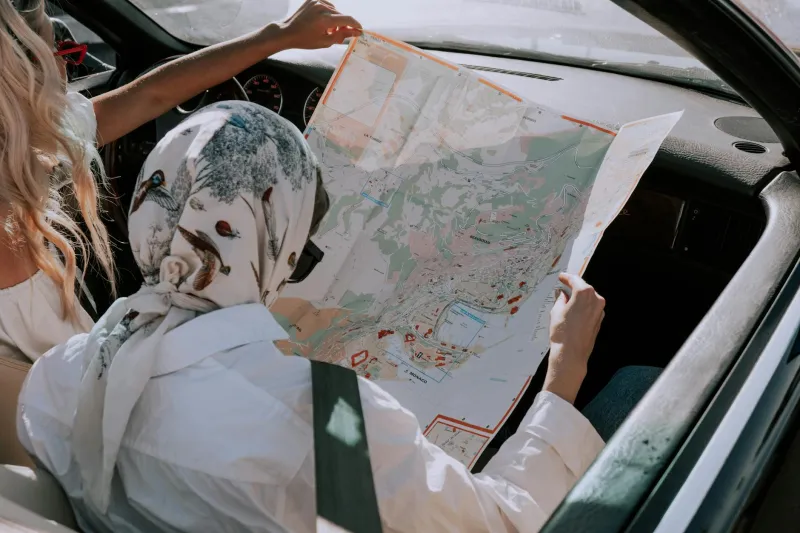
Step off a plane in 1985 in Denver, Chicago, or any unfamiliar American city, and your first stop wasn't the rental car counter—it was the airport newsstand. There, among the magazines and overpriced snacks, sat thick folded maps that would become your lifeline. These weren't the sanitized, algorithm-optimized routes we follow today. They were sprawling paper puzzles that demanded you understand where you actually were.
The ritual began before you even left the terminal. Find a quiet corner, unfold the map (usually upside down the first time), and spend twenty minutes just looking. Not searching for a specific route, but absorbing the city's skeleton—how the numbered streets ran, where the river cut through downtown, which highways formed the outer ring.
The Art of Human GPS
What happened next was something our smartphone generation has never experienced: you had to build a mental model of an entire city from scratch. Gas station attendants became unofficial tour guides, drawing routes on napkins with the confidence of seasoned cartographers. "Take Main Street until you hit the big Texaco sign—you can't miss it—then hang a left at the church with the blue steeple."
These directions weren't just functional; they were stories. Landmarks weren't GPS coordinates but living pieces of a community's identity. The diner where truckers stopped. The billboard that had been there since the 1960s. The hill where you could see the whole valley spread out below.
Americans developed what researchers now call "spatial memory"—a three-dimensional understanding of place that went far beyond knowing how to get from Point A to Point B. You learned that downtown was a grid, but the suburbs curved and twisted. You discovered that the east side had character while the west side had chain restaurants. You found shortcuts that weren't on any map because they involved cutting through a parking lot or taking a residential street that somehow connected two major roads.
The Wrong Turn Advantage
Getting lost wasn't a failure—it was education. Every wrong turn revealed something: a neighborhood you didn't know existed, a restaurant that looked interesting, a view of the city you'd never planned to see. These accidental discoveries created what urban planners call "serendipitous exploration," the kind of unexpected encounters that made cities feel alive and full of possibility.
Business travelers from that era developed an almost supernatural ability to navigate. They could draw you a mental map of downtown Seattle or explain the best route through Atlanta traffic without consulting anything but memory. They knew which hotels sat near which landmarks, which neighborhoods to avoid after dark, and how long it really took to get anywhere during rush hour.
When Every Direction Was a Conversation
Perhaps most remarkably, navigation was inherently social. You couldn't just tap a screen—you had to talk to people. Hotel desk clerks, waitresses, cab drivers, and random pedestrians all became part of your journey. These interactions weren't just about getting directions; they were tiny windows into local culture.
"Oh, you're going to the art museum? Well, you could take Fifth Street, but if you've got time, take the scenic route along the river. Much prettier." These conversations revealed not just how to get somewhere, but why it mattered, what made it special, and what locals thought you should know.
The Death of Spatial Intelligence
Today's navigation is undeniably more efficient. We arrive at destinations faster, with less stress, and rarely end up truly lost. But something profound was traded away in that exchange. Modern Americans often can't give directions to their own neighborhoods without consulting their phones. We follow blue dots without understanding the broader geography around us.
Research from the University of London found that GPS users show decreased activity in the hippocampus, the brain region responsible for spatial memory and navigation. We're literally losing the neural pathways that once helped us understand and remember places.
What We Lost in the Translation
The old way of navigation created what geographers call "place attachment"—an emotional connection to specific locations based on personal experience and discovery. When you've spent an afternoon wandering through a city's streets, making mental notes and building your own understanding of how it all fits together, you develop a relationship with that place that no algorithm can replicate.
Modern travelers often describe feeling like they never really "learn" the cities they visit. They can get around efficiently, but they leave without understanding the place's logic, its personality, or its hidden corners. The blue dot gets them there, but it doesn't help them belong.
The Deeper Navigation
Looking back, those paper maps and hand-drawn directions weren't just tools for getting around—they were invitations to truly inhabit a place, even temporarily. They forced Americans to slow down, pay attention, and engage with their surroundings in ways that created lasting memories and genuine understanding.
In our rush to eliminate the inefficiencies of getting lost, we may have also eliminated one of the most human ways of connecting with the world around us: the simple act of figuring out where we are, one wrong turn at a time.